Did you know ships can save more than 13,000 kilometers using the Panama Canal? 🌍
In this short video, we explain how this famous canal connects the Atlantic Ocean and the …Pacific Ocean, and how ships pass through it using lock chambers.
Before the Panama Canal was built in 1914, ships had to travel all the way around South America, which took more time and fuel. Today, this canal plays a huge role in global trade, shipping routes, and marine transportation.
⚙️ What you’ll learn in this video:
• How the Panama Canal works
• Why ships move up and down in lock chambers
• Why the Panama Canal is an engineering wonder
• How it changed world trade forever
👇 Comment and tell us what topic you want next!
Like 👍 Share 🔁 Subscribe 🔔
Did you know ships can save more than 13,000 kilometers using the …
Did you know ships can save more than 13,000 kilometers using the Panama Canal? 🌍
In this short video, we explain how this famous canal connects the Atlantic Ocean and the …Pacific Ocean, and how ships pass through it using lock chambers.
Before the Panama Canal was built in 1914, ships had to travel all the way around South America, which took more time and fuel. Today, this canal plays a huge role in global trade, shipping routes, and marine transportation.
⚙️ What you’ll learn in this video:
• How the Panama Canal works
• Why ships move up and down in lock chambers
• Why the Panama Canal is an engineering wonder
• How it changed world trade forever
👇 Comment and tell us what topic you want next!
Like 👍 Share 🔁 Subscribe 🔔
Discover the Volga River, the longest river in Europe, flowing …
Discover the Volga River, the longest river in Europe, flowing entirely through Russia for over 3,530 km 🌍
Learn about the origin of the Volga River, where it starts in the …Valdai Hills, where it drains into the Caspian Sea, and its major tributaries like the Kama and Oka Rivers.
Can you guess the second longest river in Europe? 🤔
Comment your answer below!
This short explains:
• Volga River facts
• Longest river in Europe
• Rivers of Europe
• Geography shorts
• World rivers
• Russia geography
• Caspian Sea facts
👉 Watch till the end and follow for more geography facts shorts!
#shorts #geography #river #europe #russia #worldgeography #geopolitics #gk #gkquiz #quiz #knowledge #facts #upsc #sscShow More
Now Playing
Mississippi River Facts That Will Blow Your Mind 🌊
This one river helped shape an entire nation 🌊 In this short video, …
This one river helped shape an entire nation 🌊
In this short video, discover how the Mississippi River became the backbone of the United States — from trade and transportation to …geography and history.
The Mississippi River is the largest river system in North America, flowing over 3,760 km from Lake Itasca in Minnesota to the Gulf of Mexico. Along the way, major rivers like the Missouri River, Ohio River, Tennessee River, and Arkansas River join it, creating one of the most powerful and important river networks in the world.
Learn amazing facts about:
• Where the Mississippi River starts and ends
• Why it is so important to America
• How it shaped trade, cities, and civilization
• What makes its bird-foot delta unique
If you love geography, history, facts, and nature documentaries, this short is for you!
👉 Like, share, and subscribe for more mind-blowing geography and history shorts!
How did 10 countries unite to form ASEAN? 🤝 Learn about ASEAN full …
How did 10 countries unite to form ASEAN? 🤝
Learn about ASEAN full form, ASEAN members, ASEAN history, AFTA agreement, and first ASEAN summit in this short video!
ASEAN (Association of Southeast …Asian Nations) was formed in 1967 through the Bangkok Declaration.
The ASEAN Free Trade Area (AFTA) was signed in 1992 in Singapore to promote free trade.
The first ASEAN Summit was held in 1976 in Bali, Indonesia.
Who Rules Your State? | India Political Map 2026 🇮🇳
Discover the political map of India in 2026 with this state-wise …
Discover the political map of India in 2026 with this state-wise breakdown of ruling parties across all Indian states and Union Territories.
This animated geography video shows who governs where in …India, from Jammu & Kashmir to the southern states and the North-East.
Perfect for students, UPSC aspirants, geography lovers, and anyone interested in Indian politics, maps, and current affairs.
Watch till the end to find your state on the map 🇮🇳
This video explains the Mekong River, the longest river in Southeast …
This video explains the Mekong River, the longest river in Southeast Asia that flows through six countries and supports millions of people.
Starting from the Tibetan Plateau in China, the Mekong …River passes through Yunnan Province, forms natural borders between Laos and Thailand, and then flows into Cambodia. It plays a major role in agriculture, fishing, transportation, and the economy of the region.
Learn amazing facts about one of the most important rivers in Asia and why the Mekong is called the lifeline of Southeast Asia.
This Tiny Strait Controls 20% of the World's Oil 😳 #geography #geopolitics
Discover how a tiny stretch of water controls 20% of the world’s oil …
Discover how a tiny stretch of water controls 20% of the world’s oil supply 🌍🛢️
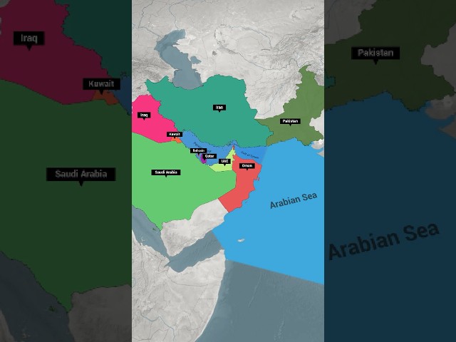
The Strait of Hormuz connects the Persian Gulf to the Gulf of Oman and the Arabian …Sea, making it the most important energy chokepoint on Earth.
Every day, millions of barrels of crude oil, LNG, and cargo ships pass through this narrow strait between Iran and Oman. Because of this, the Strait of Hormuz plays a huge role in global trade, oil prices, geopolitics, and international security.
In this short video, you’ll learn:
• Why the Strait of Hormuz is so important
• How it connects the Persian Gulf, Gulf of Oman, and Arabian Sea
• Why it affects oil prices, shipping routes, and world politics
💬 Comment below: Which is the longest strait in the world?
This Country Has 700 Rivers for 170 Million People
Discover the country with 700 rivers and over 170 million people — one …
Discover the country with 700 rivers and over 170 million people — one of the most densely populated nations on Earth! 🌍
This short reveals surprising facts about Bangladesh, including its …rivers, population density, economy, garments industry, and global impact.
Can you guess the country before the reveal? 😲👇
Watch till the end and comment your guess!
Bangladesh facts, geography facts, world facts, most populated countries, countries with most rivers, Bangladesh population, Bangladesh economy, garment industry Bangladesh, educational shorts, viral shorts, YouTube Shorts facts, amazing facts, did you know, country facts, Asia facts
Learn all the Doabs of the Indus River system in just 30 seconds! 🌍 …
Learn all the Doabs of the Indus River system in just 30 seconds! 🌍
This short explains what a Doab is and helps you remember the Bist Doab, Bari Doab, Rechna …Doab, Chaj Doab, and Sindh Sagar Doab easily.
Perfect for students preparing for SSC, UPSC, State PCS, Railways, NDA, and other competitive exams.
Watch till the end and test yourself! 👇
Keywords:
Doabs of Indus River, Doab geography, Indus river system, Indian geography shorts, Pakistan geography, rivers of India, rivers of Pakistan, competitive exam geography, SSC geography, UPSC geography, general knowledge shorts, learn geography fast, geography in 30 seconds, Terra and Time
How the Indian Plate shaped more than just the Himalayas #geology #gkfacts #shorts
Discover the fascinating geological story behind the Andaman and …
Discover the fascinating geological story behind the Andaman and Nicobar Islands 🌍
Did you know these islands were formed due to a massive tectonic plate collision between the Indian Plate, Eurasian …Plate, and Burma Plate around 50 million years ago?
In this short, learn:
• How the Indian Plate collided with the Eurasian Plate to form the Himalayas
• How the same movement created the Andaman and Nicobar Islands
• Why these islands are considered an extension of the Arakan (Rakhine) Yoma Range of Myanmar
• The role of plate tectonics, continental drift, and geological uplift
Perfect for geography, earth science, UPSC, SSC, competitive exams, and general knowledge lovers.
📌 Watch till the end to understand the real origin of this tropical paradise!
India's oldest mountain range older than Himalayas #mountains #gkfacts #shorts
India’s oldest mountain range revealed! ⛰️ In this short video, …
India’s oldest mountain range revealed! ⛰️
In this short video, explore the ancient Aravalli Range, formed nearly 570 million years ago during the Precambrian period — much older than the Himalayas!
🔍 …What you’ll learn in 60 seconds:
• Oldest mountain range of India
• Aravalli Range map: Gujarat to Rajasthan, Haryana & Delhi
• Highest peak – Guru Shikhar (Mount Abu)
• Rivers originating from Aravalli: Luni, Sabarmati, Banas
• Important facts for UPSC, SSC, State PSC & Railways
Perfect for Geography GK, Indian Physical Geography, and competitive exams 🇮🇳
🎯 Like • Share • Subscribe for more short & powerful exam facts!
#shorts #geography #aravali #aravalihills #mountains #currentaffairs #indiangeography #gkfacts #gkshorts #educational #facts #gk #upsc #ssc #railwayShow More
Now Playing
You Had NO Idea How Deep This River Goes 😳 #brahmaputra #didyouknow
**🌊 India’s Deepest River Revealed! 🌊 Did you know the Brahmaputra …
**🌊 India’s Deepest River Revealed! 🌊
Did you know the Brahmaputra River is so deep that two Qutub Minars could fit inside it? With a maximum depth of 135 meters (450 …feet), it is India’s deepest river — and more than 4× deeper than the Ganga River!
Learn about its origin from the Yarlung Tsangpo in Tibet, its names like Siang, Dihang, Luit & Jamuna, and how it becomes the world’s second-largest river by water volume.
Tell us in the comments — Which is the deepest river in the world? 🌍**