India is a vast and diverse country with unique geographical features that influence its climate, natural resources, and human activities. Understanding the basic geography of India is essential for students, This article will cover the fundamental aspects of Indian geography, including location, neighboring countries, important straits, and states with international borders.
1. Location, Latitude, Longitude, Time Zone, and Borders
Location and Extent
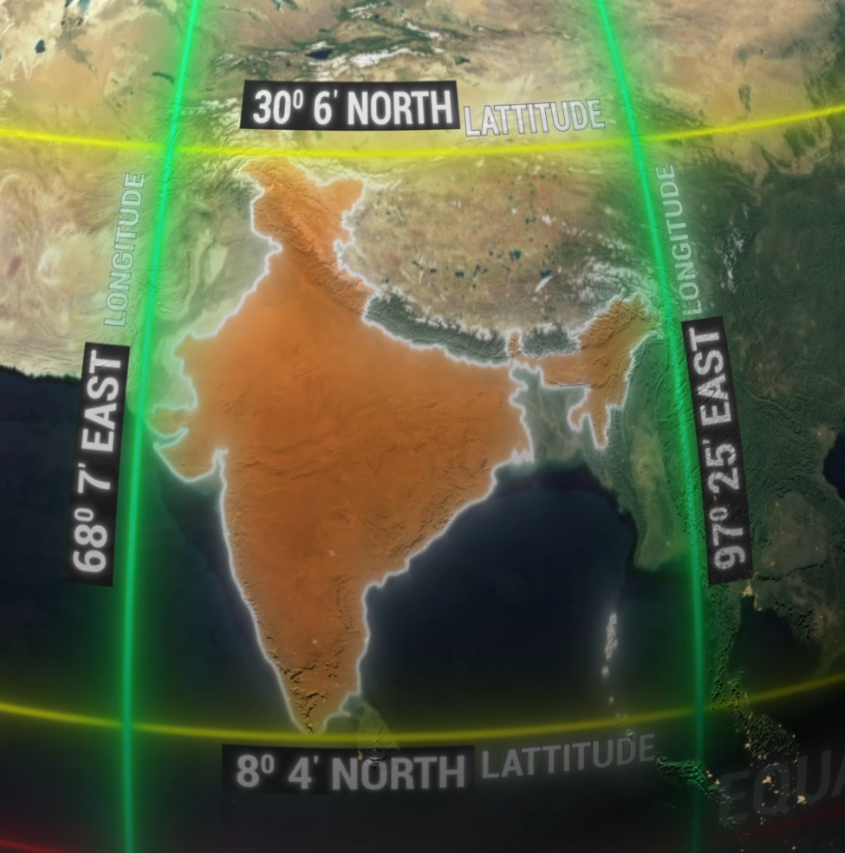
India is located in the northern hemisphere and eastern hemisphere, lying between:
- Latitudes: 8°4′ N to 37°6′ N
- Longitudes: 68°7′ E to 97°25′ E
The Tropic of Cancer (23°26′ N) passes through the middle of India, dividing it into two halves:
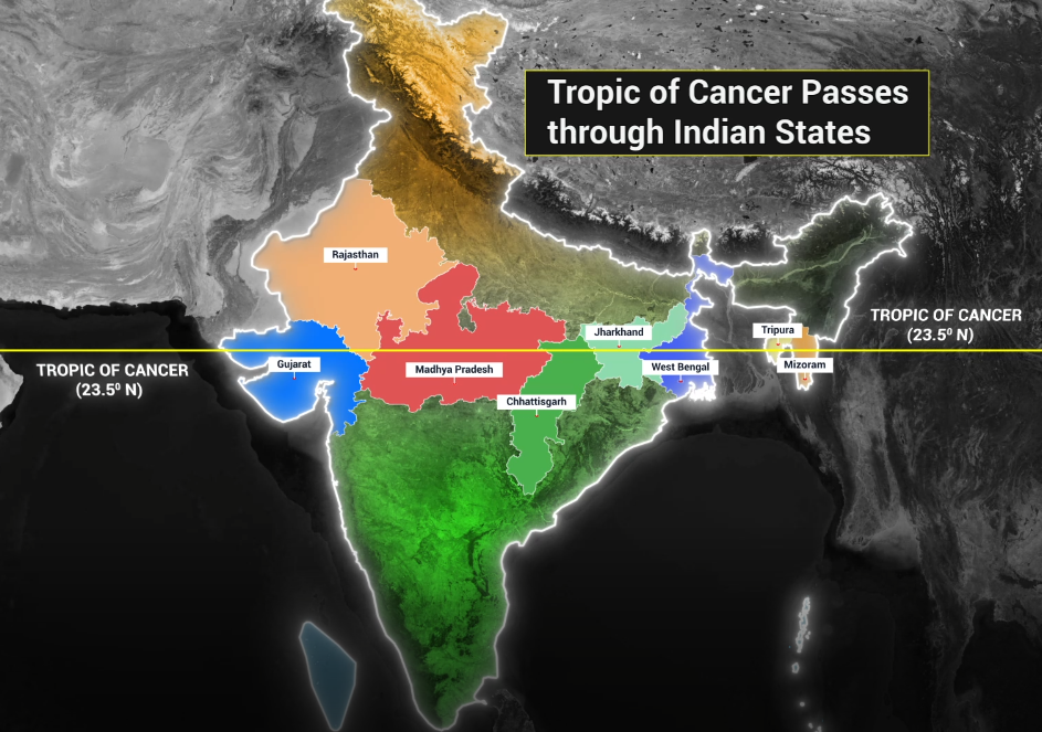
- Northern India (Temperate Zone)
- Southern India (Tropical Zone)
Tropic of Cancer passes through : Gujarat | Rajasthan | Madhya Pradesh | Chhattisgarh | Jharkhand | West Bengal | Tripura | Mizoram
Time Zone
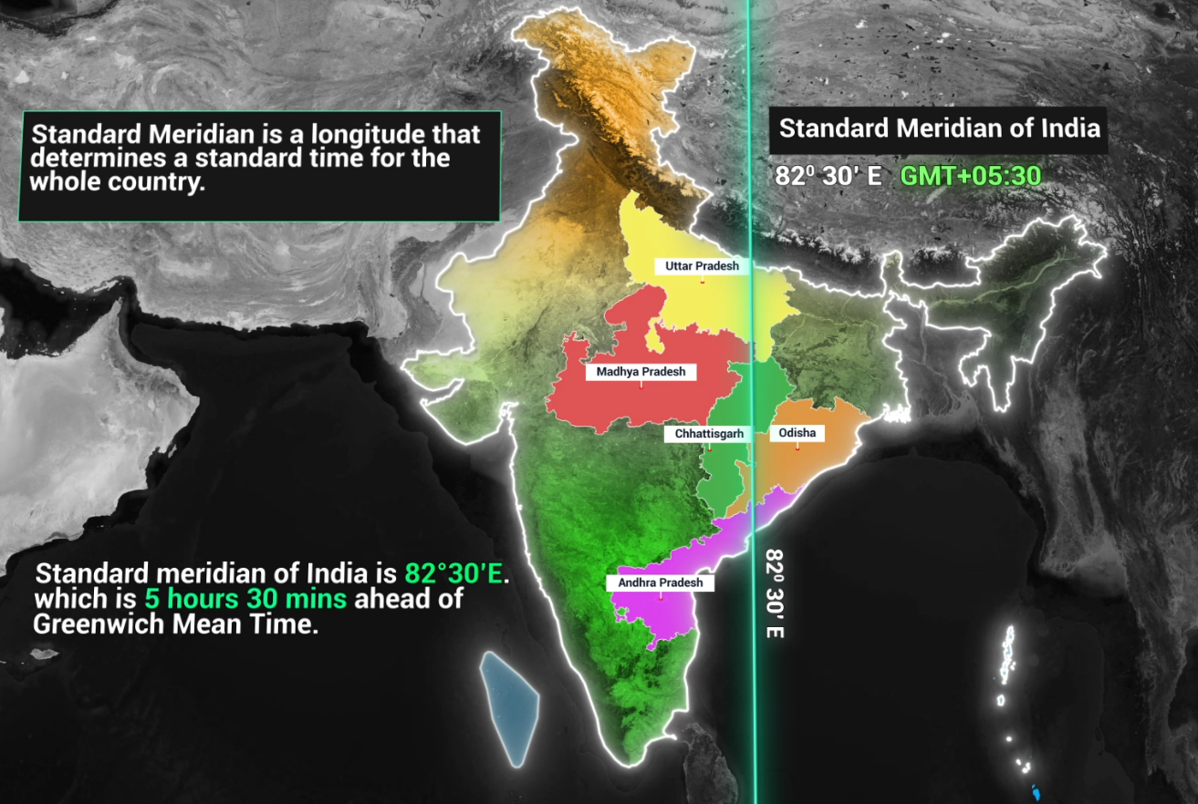
- India follows Indian Standard Time (IST), which is UTC +5:30.
- The 82°30′ E longitude passing through Mirzapur, Uttar Pradesh, is the standard meridian for India.
- Standard Meridian of India passes through : Uttar Pradesh | Madhya Pradesh | Chhattisgarh | Odisha | Andhra Pradesh
Land Borders
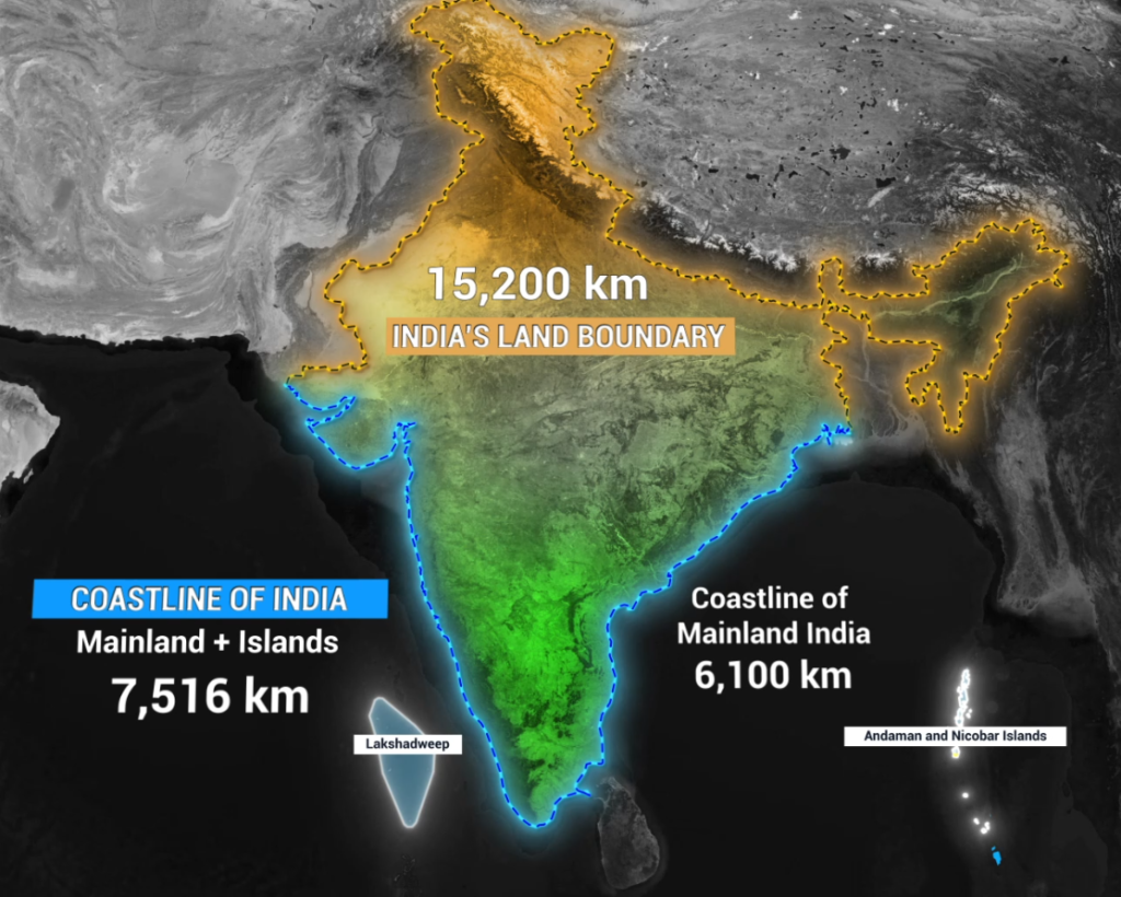
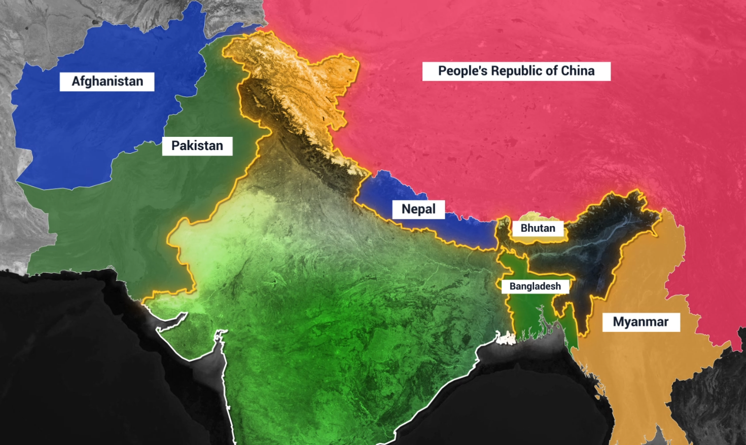
India is the 7th largest country in the world, covering 3.28 million square kilometers. It shares a 15,106 km long land border with seven countries:
- Pakistan (3,323 km) – States: J&K, Punjab, Rajasthan, Gujarat
- China (3,488 km) – States: Ladakh, Himachal Pradesh, Uttarakhand, Sikkim, Arunachal Pradesh
- Nepal (1,751 km) – States: Uttarakhand, UP, Bihar, West Bengal, Sikkim
- Bhutan (699 km) – States: Sikkim, West Bengal, Assam, Arunachal Pradesh
- Bangladesh (4,096 km) – States: West Bengal, Assam, Meghalaya, Tripura, Mizoram
- Myanmar (1,643 km) – States: Arunachal Pradesh, Nagaland, Manipur, Mizoram
Maritime Borders
India has a 7,516 km long coastline, bordering:
- Arabian Sea (West Coast) – Gujarat, Maharashtra, Goa, Karnataka, Kerala
- Bay of Bengal (East Coast) – Tamil Nadu, Andhra Pradesh, Odisha, West Bengal
- Indian Ocean (Southern Border)
Southernmost, Northernmost, Easternmost, and Westernmost Points
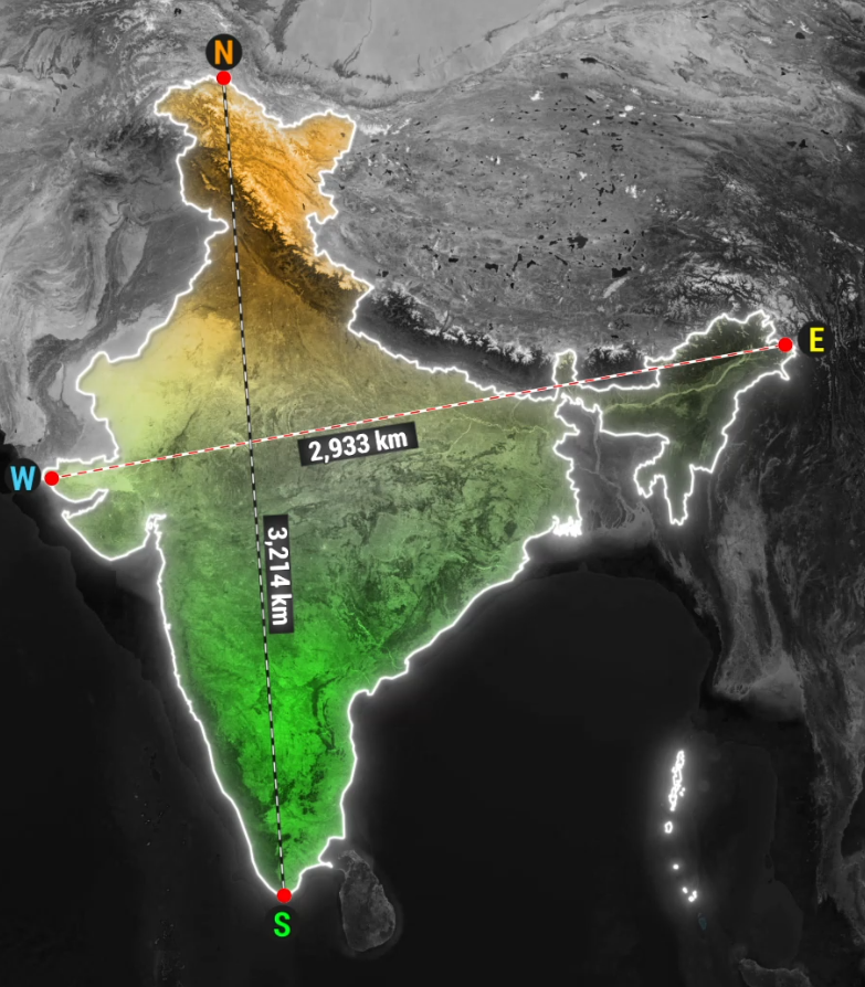
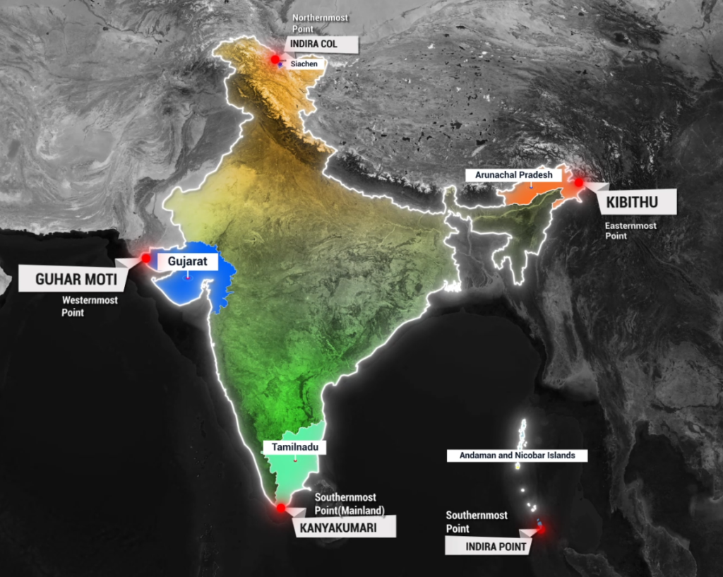
- Southernmost (Mainland): Kanyakumari, Tamil Nadu
- Southernmost (Overall): Indira Point, Nicobar Islands
- Northernmost: Siachen Glacier, UT of Ladakh
- Easternmost: Kibithu, Arunachal Pradesh
- Westernmost: Ghuar Moti, Gujarat
2. India’s Neighboring Countries
India shares its land borders with 7 countries and maritime boundaries with 2 additional nations (Sri Lanka and the Maldives).
Brief Overview of Neighboring Countries:
- Pakistan: Shares a western border; divided by the Radcliffe Line (1947).
- China: Border defined by the McMahon Line (in Arunachal) and LAC disputes.
- Nepal: Close cultural and economic ties; open border system.
- Bhutan: A small landlocked Himalayan nation, friendly relations with India.
- Bangladesh: Longest shared border with India; historical ties from 1971 war.
- Myanmar: Links India to Southeast Asia; key for Act East Policy.
- Sri Lanka: Separated by the Palk Strait; close historical and cultural links.
- Maldives: Lies in the southwest of India in the Indian Ocean.

3. Important Straits and Waterways
Straits are narrow water bodies connecting two larger water bodies. Some of the most important straits for India include:
Major Straits Near India:
- Palk Strait: Between India and Sri Lanka.
- Malacca Strait: Connects the Indian Ocean with the South China Sea, crucial for trade.
- Sunda Strait: Between Sumatra and Java, linking Indian Ocean and Pacific Ocean.
- Lombok Strait: Between Bali and Lombok, another vital trade route.
- Six Degree Channel : Lies between the Nicobar Islands and Sumatra.
- Eight Degree Channel : Maritime Boundary between India and the Maldives.
- Nine Degree Channel: Separates Lakshadweep islands (Maliku and Kalpeni).
- Ten Degree Channel: Separates Andaman and Nicobar Islands.
- Coco strait : Separates North Andaman Islands from coco islands of Myanmar.
These straits are significant for international trade, military strategy, and environmental considerations.
4. Indian States with International Borders
India has 17 states and 2 UTs sharing international borders:
States with International Borders:
- Pakistan (4 states): J&K, Punjab, Rajasthan, Gujarat
- China (5 states): Ladakh, HP, Uttarakhand, Sikkim, Arunachal Pradesh
- Nepal (5 states): Uttarakhand, UP, Bihar, West Bengal, Sikkim
- Bhutan (4 states): Sikkim, WB, Assam, Arunachal Pradesh
- Bangladesh (5 states): WB, Assam, Meghalaya, Tripura, Mizoram
- Myanmar (4 states): Arunachal, Nagaland, Manipur, Mizoram
Union Territories with International Borders:
- Ladakh: Borders China and Pakistan
- Jammu & Kashmir: Borders Pakistan and China
5. Major Physiographic Divisions of India
Indian geography is incomplete without understanding the six major physical regions:
Major Straits Near India:
- The Himalayas: The northernmost and youngest mountain range; divided into Greater Himalayas, Lesser Himalayas, and Shiwaliks.
- The Indo-Gangetic Plains: Fertile plains covering Punjab, Haryana, UP, Bihar, West Bengal.
- The Peninsular Plateau: Oldest landform, includes Deccan Plateau, Western & Eastern Ghats.
- The Coastal Plains: Western & Eastern coasts, important for ports and fisheries.
- The Indian Desert: Thar Desert in Rajasthan.
- The Islands: Andaman & Nicobar (Bay of Bengal) and Lakshadweep (Arabian Sea).
India’s geography plays a crucial role in its climate, economy, geopolitics, and cultural diversity. Its location, neighboring countries, straits, and border states all contribute to its strategic importance. Therefore, understanding these fundamentals is essential for deeper studies on climate, natural resources, population distribution, economic activities, and trade.
